Subak: Bali's Rice Irrigation System, Explained
What is subak and why does it matter for a Bali trip?
Subak is Bali's centuries-old, temple-linked cooperative system for managing rice paddy irrigation, recognised by UNESCO as part of the Cultural Landscape of Bali Province. It matters for travellers because it's the actual reason the island's rice terraces look and function the way they do, and understanding even the basics changes a rice terrace visit from a pretty view into something with real depth behind it.
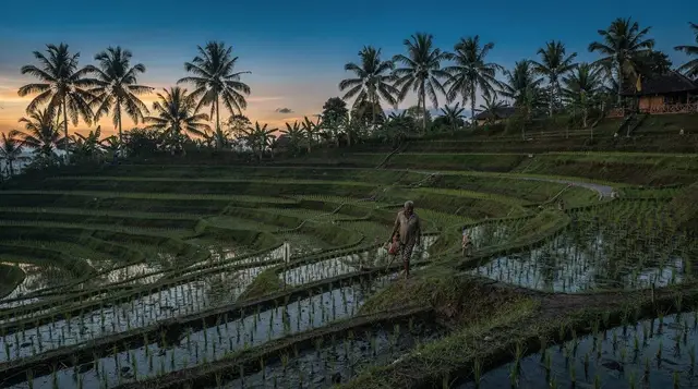
Most visitors who photograph Bali’s rice terraces never learn the word behind them. Subak is the cooperative irrigation system that has organised how water moves through the island’s rice paddies for roughly a thousand years, and it’s the reason the terraces you see at Jatiluwih, Tegalalang, or anywhere else in Bali exist in their current form at all. Understanding it, even briefly, changes what a rice terrace visit actually is — not just a scenic backdrop, but a working piece of infrastructure with a philosophy behind it that’s still shaping decisions farmers make today.
At its simplest, subak is a system of water-sharing associations, one per irrigated area, that decides collectively how water from mountain springs and rivers gets distributed fairly across every farmer’s paddies downstream. Because rice cultivation depends entirely on controlled flooding at the right times, and because water naturally runs downhill past dozens or hundreds of separate plots before reaching the sea, this kind of cooperative management isn’t optional — without it, farmers upstream could simply take what they wanted and leave those below with nothing. Subak solves that problem through a mix of physical infrastructure, religious ritual, and enforceable community agreement.
What earned the system UNESCO recognition in 2012, as part of a listing covering several sites across Bali including Jatiluwih and the Batukaru temple, wasn’t the engineering alone. It was the underlying philosophy, Tri Hita Karana, which loosely translates as “three causes of well-being” and ties together harmony between people, harmony between people and nature, and harmony between people and the spiritual realm. Subak isn’t purely a technical irrigation network — every stage of water distribution is bound up with temple ritual, and the water temples scattered through Bali’s rice-growing regions aren’t decorative additions to the landscape; they’re functioning parts of how the system operates.
Subak at a glance
| What it is | A centuries-old cooperative irrigation system managing water for Bali’s rice terraces |
| Recognition | UNESCO World Heritage listing since 2012, as part of the Cultural Landscape of Bali Province |
| Where to see it | Jatiluwih (the core listed site), also visible at Tegalalang and other terraced areas |
| Philosophy | Tri Hita Karana — balance between people, nature, and the spiritual realm |
| Best way to learn more | A guided walk or cultural tour through a working subak-managed valley |
How the water actually moves
Water for subak-managed rice terraces originates in mountain springs, crater lakes, and rivers in Bali’s volcanic highlands, then travels through a network of channels, tunnels, and small canals down toward the coast, passing through hundreds of individually farmed plots along the way.
Each subak association — essentially a farmers’ cooperative tied to a specific water source — decides collectively on a rotation schedule for flooding different sections of terracing, ensuring that no single farmer’s fields dominate the flow at the expense of everyone downstream. This isn’t an informal arrangement; subak associations have functioned for centuries as genuine governing bodies with real authority over water allocation, separate from and older than modern government irrigation authorities.
The engineering itself is often deceptively simple to look at — a channel here, a small dam there — but the cumulative system moving water across an entire watershed, timed to serve dozens of separate cooperative groups fairly, represents a level of sustained coordination that’s easy to underestimate on a quick visit.
Water temples: the spiritual side of the engineering
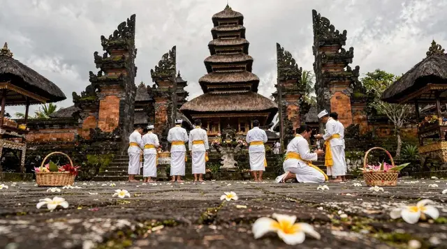
Scattered through Bali’s rice-growing regions are water temples, ranging from small shrines at individual channel junctions to significant complexes like Pura Ulun Danu Batur at the crater lake that feeds much of central Bali’s irrigation. These temples aren’t symbolic additions layered onto a purely technical system — traditionally, priests at key water temples played (and in many places still play) a genuine role in coordinating the timing of water releases and planting cycles between different subak groups, blending religious authority with practical water management in a way that’s distinctive to Bali specifically.
Where to actually see subak working
Jatiluwih is the site most closely tied to the UNESCO listing and the best place to see the system at real scale, with trails running through kilometres of working terracing and multiple water temples visible along the way. A private buggy journey through the Jatiluwih rice terraces covers more of this ground in less time than walking would, useful if you want to see the scale of the system without committing to a long hike.
For a deeper cultural framing rather than just the view, a Jatiluwih cultural experience including lunch typically builds in more explanation of how the system and the surrounding farming community actually function, alongside a meal using rice grown in the same valley.
Beyond Jatiluwih, the wider Batukaru area further up the slope connects the rice terraces to Pura Luhur Batukaru, one of Bali’s most significant directional temples and a genuine node in the subak network rather than an unrelated stop. A combined tour of Batukaru temple, a waterfall, and the surrounding rice terraces ties these pieces together in a way that’s harder to piece together independently without local knowledge of how the sites relate.
The cooperative structure, in practical terms
Each subak typically has its own set of leaders, meeting schedule, and rules for how members contribute labour and resources to maintaining shared infrastructure like channels and small dams. Disputes over water allocation are resolved within this structure rather than through outside authorities in most cases, which has allowed subak to function as a genuinely self-governing system for far longer than most comparable agricultural cooperatives elsewhere in the world. Farmers who don’t maintain their section of shared infrastructure, or who take more than their allotted share, face real consequences within the community rather than just informal disapproval.
This cooperative model is also credited by researchers with helping Bali sustain rice cultivation at a scale and reliability that supported dense population growth over centuries, in terrain that would otherwise make large-scale irrigation extremely difficult given the steep volcanic slopes involved.
Rice, ceremony, and everyday Balinese life
Rice occupies a place in Balinese Hindu life well beyond its role as a food crop, and subak is inseparable from that wider cultural context. Dewi Sri, the rice goddess, is honoured at various points through the planting and harvest cycle, and small shrines dedicated to her are a common sight at the edge of working paddies across the island, distinct from the larger water temples that manage the irrigation system itself. Offerings tied to rice cultivation form part of the same daily and periodic ceremonial rhythm that shapes so much of Balinese life more broadly, connecting the practical work of growing food to the island’s dominant religious framework in a way that’s hard to fully separate.
This is worth knowing not because it changes how you walk through a rice terrace, but because it explains why the terracing feels different from farmland elsewhere — it’s simultaneously agricultural infrastructure, religious landscape, and, more recently, a tourist draw, with all three roles layered on top of each other rather than existing separately.
What isn’t worth the detour
Skip treating a subak-focused visit as purely a technical or academic exercise if that’s not genuinely what interests you — for most travellers, the more rewarding approach is simply walking through Jatiluwih or a similar site with a bit of context in mind, rather than seeking out a dedicated lecture-style explanation. It’s also not worth trying to visit every water temple along a route in a single day chasing a complete picture of the system; a couple of well-chosen stops, understood properly, teach you more than rushing past a dozen shrines without context.
Threats the system faces today
Subak isn’t a static, guaranteed-forever arrangement, and it’s worth understanding the pressures it faces even as a casual visitor. Land conversion for tourism development, villa construction, and the general economic pull toward non-agricultural work have all reduced the amount of land under subak management in parts of Bali over recent decades, particularly closer to the tourist-heavy south. Jatiluwih and similarly protected areas have benefited from the UNESCO listing and associated conservation attention, but the pressure on rice land elsewhere on the island is real and ongoing, with younger generations in some farming families choosing tourism or other industries over continuing the labour-intensive work of rice cultivation.
None of this needs to weigh on a single visit, but it’s part of why some communities and conservationists frame tourist interest in subak, done respectfully and with genuine spending that reaches local farmers, as one of the few economic incentives currently working in favour of keeping working rice land as working rice land rather than converting it to other uses.
What it costs
Learning about subak doesn’t have a separate cost beyond visiting the sites where it’s visible — Jatiluwih’s entrance fee covers trail access to the working landscape, and guided tours or cultural experiences that include explanation of the system are priced as a standard tour rather than carrying any premium for the cultural content. Transport to Jatiluwih or the Batukaru area is the main cost variable, given the distance from Ubud or South Bali.
When to go
Morning visits to Jatiluwih or the Batukaru area give the best combination of clear highland views and comfortable walking conditions before the day heats up and cloud typically builds. The dry season, roughly April to October, offers more reliable weather for a longer walk through the terracing, though the system itself functions year-round regardless of season — rice cultivation in Bali isn’t limited to a single growing window the way seasonal crops elsewhere might be.
Getting there and getting around
Jatiluwih, the primary site for seeing subak at scale, requires a genuine drive up into the Tabanan highlands from Ubud or South Bali. The Batukaru area sits further up the same general slope, reachable by continuing past Jatiluwih or via a separate route depending on your starting point. A private driver is the most comfortable way to reach either, given the distance and the winding mountain roads involved, though the trip works equally well as part of an organised tour that handles the logistics for you.
How this fits into a longer trip
Subak is best understood as background to a visit rather than a separate stop, so pairing this reading with an actual trip to Jatiluwih is the most useful way to put it into practice. The dedicated Jatiluwih rice terraces UNESCO guide covers the practical visiting details in more depth, while this page focuses on the system itself.
For travellers wanting to compare the working landscape at Jatiluwih with the busier, more compact experience at Tegalalang, the Tegalalang rice terrace guide is worth reading alongside this one. A highland day built around subak and its temples fits naturally into the north and west Bali, 4 days itinerary or a longer stay based around Tabanan and Bedugul.
Frequently asked questions about Subak
Is subak still actively used, or is it mostly historical now?
It’s still active. Subak associations continue to manage water distribution for rice cultivation across much of Bali today, and the UNESCO listing recognises a living system rather than a preserved historical artefact.
Why did subak specifically earn UNESCO recognition rather than just “Bali’s rice terraces”?
The listing recognises the cooperative management system and its underlying philosophy, Tri Hita Karana, not the terracing as scenery. Jatiluwih was included as the best-preserved large-scale example of the system still functioning as designed.
Do I need a guide to understand subak, or can I learn enough on my own?
A guide adds real value here, since the water temples and channel systems along the trails aren’t well explained by on-site signage. That said, reading a bit beforehand, as you’re doing now, and then walking through Jatiluwih independently still gives a meaningful sense of the system.
Is subak unique to Bali, or does similar irrigation exist elsewhere?
Cooperative irrigation systems exist in various forms across rice-growing regions of Southeast Asia and beyond, but the specific combination of subak’s structure with the Tri Hita Karana philosophy and integrated water-temple network is distinctly Balinese.
Can I visit a water temple that’s part of the subak system?
Yes, several are open to respectful visitors, including smaller shrines along the Jatiluwih trails and the larger Pura Luhur Batukaru further up the slope. Standard temple etiquette, including a sarong, applies at any of them.
Does the subak system affect where I can walk in the rice terraces?
To some extent — the trails at sites like Jatiluwih are set to avoid disrupting active irrigation channels and working paddies, so staying on marked paths matters both for your own safety and for the farmers relying on that infrastructure.
Is subak the reason Bali’s rice terraces look different from terraces elsewhere in Indonesia?
It’s a significant part of it. The specific cooperative governance and water-temple integration shape both how the terraces are laid out and how consistently they’ve been maintained across centuries, which is part of why Bali’s terraced landscapes read as unusually intact and functional compared to some other regions.
Rice terrace & countryside tours on GetYourGuide
Verified deep-linked GetYourGuide tours. Book through these links and we earn a small commission at no cost to you.
These are our own photographs of Bali, not the operator's pictures of this tour — open the tour page to see those.