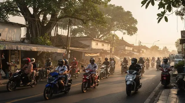
Why Bali Traffic Is So Bad, and How to Actually Plan Around It
Ask anyone who’s spent real time in Bali what surprised them most, and traffic is a genuinely common answer — not because Bali is uniquely large or its distances uniquely great, but because the mismatch between actual driving time and what the map suggests is often dramatic. A route that Google Maps estimates at 25 minutes can regularly take 45 minutes to an hour during the wrong part of the day, and this isn’t an occasional bad-luck event; it’s a structural feature of how the island’s roads and vehicle volume interact, worth understanding and planning around rather than treating as a series of unlucky days.
The core cause is straightforward: Bali has no metro, no train, and essentially no meaningful mass transit system to absorb the movement of both residents and the huge volume of visitors the island receives, which means every journey — commuter, tourist, and delivery vehicle alike — competes for the same finite road space. Scooters, which vastly outnumber cars on Bali’s roads, are individually nimble but collectively add enormous volume, and Bali’s roads, particularly in the densest tourist areas, were largely built for a much smaller population and vehicle count than they now carry.
Geography compounds the problem in specific ways too. South Bali’s tourist areas — Kuta, Legian, Seminyak, Canggu — sit close together but are connected by a limited number of main arteries, meaning a relatively small road network absorbs a disproportionate share of the island’s total traffic. Canggu in particular has become a well-known bottleneck as its own popularity has outpaced infrastructure built for a much quieter beach town a decade or two ago, and its narrow lanes, originally built for local agricultural and residential use, now carry far more vehicles than they were designed for.
At a glance
| Core cause | No mass transit system; road network built for a much smaller vehicle volume than it now carries |
| Worst areas | Canggu, Seminyak, and the Kuta-Denpasar corridor, particularly during peak hours |
| Worst times | Weekday commuter hours (roughly 7-9am and 4-7pm) and any period around a major ceremony affecting road closures |
| Practical fix | Build in real time buffers, travel during off-peak windows where possible, and consider a private driver for multi-stop days |
| What doesn’t help | Assuming the map’s estimated time is realistic without checking current conditions |
Why South Bali specifically is the worst of it
Kuta, Legian, Seminyak, and Canggu form a fairly continuous, densely populated tourist and residential corridor, and the roads connecting them weren’t laid out with this volume of both local and tourist traffic in mind. Add narrow lanes in older, more established parts of Seminyak and Canggu, frequent roadside parking that further narrows already tight roads, and a high concentration of scooters weaving between slower-moving cars, and the result is a corridor that regularly bottlenecks regardless of the actual distance between two points within it.
Ceremony-related road closures
Beyond everyday congestion, Bali’s frequent religious ceremonies — from small, local temple observances to island-wide events like Galungan — can involve temporary road closures for processions, which catch visitors off guard if they’re not expecting them.
These closures are usually brief and localised but can add meaningful delay if you happen to be travelling through the affected area at the wrong moment, and a driver or guide familiar with the local calendar will often know to route around a planned procession in advance, which is one of the underappreciated benefits of hiring local transport over self-navigating with a map app alone. A brief message to your driver or host the evening before, simply asking whether any ceremonies are planned along your intended route the next day, is a low-effort habit that occasionally saves a genuinely frustrating unplanned detour.
Self-driving versus hiring a driver
For getting around within a single area, a scooter remains genuinely practical and often faster than a car precisely because it can navigate around the worst of the congestion. For longer, multi-stop days or travel between distant regions of the island, a private driver who knows current road conditions and alternative routes is generally the more time-efficient and less stressful option, even accounting for the extra cost.
A full-day option built around this, such as a Denpasar private snorkel and city tour with hotel transfers, folds the transport logistics into the booking itself, which removes the traffic-planning burden from you entirely for that day. This is generally the more relaxing choice for a day already involving several separate activities, since the mental overhead of route planning and timing buffers is handled by someone with direct, current knowledge of the roads rather than left to your own best guess.
| Scooter | Private driver | Ride-hailing app | |
|---|---|---|---|
| Best for | Short, local trips within one area | Multi-stop days, longer distances | Point-to-point trips, no rental commitment |
| Traffic navigation | Good, can weave through congestion | Good, driver knows current conditions | Depends on the individual driver’s route knowledge |
| Effort required | High (requires licence, confidence riding) | Low | Low |
Peak hours and how to plan around them
Weekday mornings (roughly 7-9am) and evenings (roughly 4-7pm) are the most reliably congested windows, driven by local commuter traffic layered on top of tourist movement. Scheduling activities to start either well before or well after these windows, where your itinerary allows it, meaningfully reduces the amount of time lost sitting in traffic compared with a schedule that inadvertently books every transition during peak hours.
Denpasar as an underappreciated traffic factor
Denpasar, Bali’s capital and largest city, isn’t typically a tourist destination in its own right, but it sits at a genuine transport crossroads that a lot of cross-island journeys pass through or near, and its traffic can add real delay to routes that appear on a map to bypass the city centre entirely. A city-focused stop like the heritage street food tour through Denpasar’s Badung Market is a reasonable way to make productive use of a Denpasar stop if your route passes through anyway, rather than treating the city purely as unavoidable transit friction.
The gap between locals’ shortcuts and what a map app suggests
One detail that surprises a lot of visitors relying purely on a navigation app is how often the “fastest” suggested route isn’t actually the fastest in practice, because map apps generally optimise for distance and posted road type rather than real-time local knowledge of which back lane bypasses a known bottleneck.
Local drivers, both taxi and private hire, frequently use routes a map app wouldn’t prioritise — a slightly longer distance on paper that avoids a chokepoint everyone who drives the route regularly already knows to skip. This is one of the genuine, underappreciated arguments for a knowledgeable local driver over pure self-navigation, beyond simply not having to focus on the road yourself: their route knowledge is often meaningfully better than what an app alone provides, particularly on Bali’s less well-mapped secondary roads.
How infrastructure projects are (slowly) changing this
It’s worth noting that Bali’s traffic problem hasn’t gone unnoticed by local government, and various road-widening and new-route projects have been underway in different parts of the island to address the worst bottlenecks. Progress is real but gradual, and any specific improvement tends to be localised rather than solving the island-wide pattern in one move, so it’s sensible to plan around current, on-the-ground conditions rather than assuming infrastructure improvements will have meaningfully changed the picture by the time of a near-term trip. Checking recent traveller reports or asking your accommodation directly about current conditions on a specific route is more reliable than assuming a general improvement applies uniformly.
Building buffer time into a multi-stop itinerary correctly
A practical approach that works well in practice: for any day involving more than a single destination, add at least fifty percent more time than a map app’s estimate between each stop, and more again if any leg passes through Seminyak, Canggu, or the Kuta-Denpasar corridor during a weekday. This sounds like a large adjustment, but it consistently proves closer to reality than the map’s raw estimate, and building it in from the start avoids the cascading stress of a day where every subsequent stop runs later than planned because the first leg alone ran over.
What isn’t worth the detour
Skip assuming a map app’s estimated travel time is reliable during peak hours without checking live traffic conditions first — the gap between estimated and actual time is often largest precisely when you can least afford it, such as an airport transfer for a flight. Also skip scheduling more than two or three separate stops in a single day across different parts of South Bali; the temptation to pack in more sights is understandable, but Bali’s road conditions punish an ambitious multi-stop day far more than the map distances suggest they should.
Budget
A private driver for a full day costs more than a series of individual ride-hailing trips but often works out reasonable once you account for the time saved navigating multiple bookings and potential surge pricing during peak hours. Scooter rental remains the cheapest option for local, single-area travel, though the cost of a genuine accident or fine for riding without proper licensing is worth weighing against the savings, particularly for less confident riders.
When to go
Traffic patterns don’t shift dramatically by season, though peak tourist periods (July-August, December-January) add tourist vehicle volume on top of the baseline commuter congestion, making already busy corridors like Canggu and Seminyak measurably worse during these specific windows. Planning activities slightly earlier or later in the day during peak season is a more effective adjustment than trying to avoid busy season travel altogether.
Access and getting there
For inter-island travel that avoids road traffic entirely, boat options such as the Gili Islands and Lombok fast boat ticket sidestep the mainland road network for that leg of a trip, which is worth considering if a multi-day itinerary includes both Bali and the islands to the east. For airport-adjacent journeys specifically to or from Ubud, a transfer like the Ngurah Rai International Airport DPS to Ubud transfer accounts for the realistic travel time on this specific, traffic-heavy route rather than relying on an optimistic map estimate.
How this fits into a longer trip
For the broader practical picture of getting around the island, the getting around Bali guide, Grab and Gojek in Bali guide, and hiring a private driver guide all build on the traffic realities covered here with more specific booking and app guidance. If you’re comparing where to base yourself specifically to minimise daily traffic exposure, the Kuta versus Seminyak versus Canggu comparison is worth reading alongside this page.
For destination-specific detail on the areas most affected by congestion, see the Canggu destination guide, Seminyak destination guide, and Denpasar destination guide. The scooter rental and licence guide is essential reading before choosing self-driving as your primary way of navigating around the congestion described on this page.
Frequently asked questions about Why Bali Traffic Is So Bad, and How to Actually Plan Around It
Why is Bali traffic so much worse than the distances suggest?
No mass transit system, a road network built for a much smaller vehicle volume, and narrow lanes in the densest tourist areas all combine to make actual travel times far longer than map estimates in many cases.
Is Canggu really the worst area for traffic?
It’s frequently cited as one of the worst, given how quickly its popularity has grown relative to its original, narrower road infrastructure, though Seminyak and the Kuta-Denpasar corridor are also consistently congested.
Should I rent a scooter to avoid traffic, or does it make things worse?
For short, local trips within one area, a scooter is often genuinely faster since it can navigate around stopped traffic. For longer cross-island journeys, the time advantage is less clear-cut.
Is hiring a private driver worth the extra cost?
For multi-stop days or longer journeys, often yes, since a driver who knows current conditions and can route around known bottlenecks or closures typically saves real time compared with self-navigating.
Do religious ceremonies really cause road closures?
Yes, processions for both small local ceremonies and larger island-wide events can temporarily close specific roads, usually briefly and locally, but worth planning around if you’re travelling through the affected area.
What time of day should I avoid travelling in Bali?
Roughly 7-9am and 4-7pm on weekdays are the most consistently congested windows, driven by local commuter traffic layered on top of tourist movement.
Does traffic get worse during Bali’s peak tourist season?
Yes, July-August and December-January bring additional tourist vehicle volume on top of the baseline congestion, making already busy corridors measurably worse during these periods.
Is there any way to avoid Bali’s traffic entirely?
Not entirely, but building genuine time buffers into your itinerary, scheduling around peak hours where possible, and using a knowledgeable driver for multi-stop days all meaningfully reduce how much of your trip is lost to it.
Transport passes & transfers on GetYourGuide
Verified deep-linked GetYourGuide tours. Book through these links and we earn a small commission at no cost to you.
These are our own photographs of Bali, not the operator's pictures of this tour — open the tour page to see those.